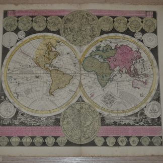
Description
Double-hemisphere world map, on a landscape background, with smaller double-hemisphere celestial maps,
small circular cartouches in the upper margin representing various global views,
small circular cartouches in the lower margin with astronomical views,
verso blank.
Latin Map Title: Planisphaerium Terrestre cum utroque Coelesti Hemisphaerio, sive Diversa Orbis Terraquei.
Translation : Flat-Earth globe with both heavenly half-round, or the various imagination of Land – Water.
Rare world map with atttactive contemporary hand-coloring.
Zürner’s world map appeared in atlases, such as Schenk’s Atlas Contractus, and later in the atlases of Ottens.
The world map is “cartographically up-to-date” (Shirley) and shows the routes of Magellan, Dampier, Tasman, Gaetani and Chaumont. (Shirley 639).
Parts of Australia and New Zealand are still undiscovered.
Greenland example yet discovered only the south coast. Australia is named “Nova Hollandia”, and California is shown as an island.
dimensions totales 25.6 x 22.05 in.
Central fold, some foxing and stains on the edges.
- DIMENSIONS
- 25.6ʺW × 0.01ʺD × 22.01ʺH
- STYLES
- Illustration
- FRAME TYPE
- Unframed
- PERIOD
- Early 18th Century
- PLACE OF ORIGIN
- France
- ITEM TYPE
- Vintage, Antique or Pre-owned
- MATERIALS
- Paper
- CONDITION
- Good Condition, Original Condition Unaltered, Some Imperfections
- COLOR
- Black
- CONDITION NOTES
- Central fold, some foxing and stains on the edges.